
I just wanted to thank all of you who have used my website through 2009.
Since the changing the URL to www.hebwx.co.uk and the website update the numbers of visitors to the site has doubled and regularly reaching over 150 per day. Not bad for a station based on an Island!! The best day was 11th January 2009, during that nights storm, when over 650 visitors from all over the world hit the site when the wind speed reached high of 85 knots (98 mph).
I have had one of my photos published in a book called Sky by Storm Dunlop, which is a bit of an honour when you see some of the other images that are in the book.
For 2010, I have been asked to write a column in our local monthly free paper "Events" and do a summary of the preceding months weather including any notable events that took place. So watch out for that if you live on the Western Isles.
So here's wishing you all a happy & prosperous New Year.
Thursday, 31 December 2009
Blue Moon
No, not the song.
Tonight is a Blue Moon, where we get the second full moon of the month, the first was on December 2nd.
Tonight is a Blue Moon, where we get the second full moon of the month, the first was on December 2nd.
Wednesday, 16 December 2009
Snow Forecast
There is a likelihood of snow and strong cold Northerly winds effecting the Highlands and Western Isles this weekend (18th to 21st December).
The Mainland will see worse conditions than the Western Isles and the strong winds will make driving conditions hazardous with blizzards likely. The Western Isles may see accumulations of snow on higher ground but sleet or snow showers are more likely at lower levels.
The current forecasts are giving wind-chill temperatures as low as -9° C for the weekend with the air temperature hovering around freezing over most of Saturday & Sunday.
You can keep an eye on the latest local forecast from Hebrides Weather and the Met Office will issue warnings and advisories if necessary.
Saturday, 28 November 2009
UV Sensor Installed
Hebrides Weather now has it's own UV sensor installed on the weather station.
I picked a good time to test the new sensor as there's hardly any UV radiation around at this time of year, it's been running for 24 hours now and it's not moved off of 0.0.
Over the next day or so I'll add the data from the UV sensor to the main dashboard on the website and to the 'Live' page as well.
One other update is to the firmware on the Davis VP2 Console, it was using v1.70 and has now been updated to the latest v1.82 (13th Jan 2009).
A bit of a nervous time as any problems could have meant that the console wouldn't restart, thus the weather data would stop. But it all went OK and the console has rebooted with no problems.
Thursday, 29 October 2009
Email Weather Alerts & Warnings
Want to be warned when the wind goes over 50 mph or if there's likely to be ice on the roads on the way to work?
Following a request on this Blog, Hebrides Weather is now offering a Weather Warning & Alert Email Service.
The way it works is this:
There are thresholds set by Hebrides Weather and if any of these (listed below) are exceeded then an email is automatically sent to all those who have requested it.
It should be stressed that these warnings & alerts are for actual weather events that have already happened, they are not an advanced warning service!!
The thresholds are as follows:
You are free to request that your email address be removed from the list at any time and your email address will not be passed to any third party.
Following a request on this Blog, Hebrides Weather is now offering a Weather Warning & Alert Email Service.
The way it works is this:
There are thresholds set by Hebrides Weather and if any of these (listed below) are exceeded then an email is automatically sent to all those who have requested it.
It should be stressed that these warnings & alerts are for actual weather events that have already happened, they are not an advanced warning service!!
The thresholds are as follows:
- Maximum wind gust above 64 knots (Hurricane Force)
- Mean wind speeds over 44 knots (50 mph)
- More than 25mm (1 inch) of rain in the last hour
- More than 50mm (2 inches) or rain in the last 6 hours
- Temperature falls below 0°C
- Temperature rises above 30°C
- Windchill falls below -15°C
- Barometric pressure rises above 1080 hPa
- Barometric pressure falls below 800 hPa
- Barometric pressure fall more than 10 hPa in 1 hour
- Time of day is between 9pm & 9am (over night)
- Dew point is less than 3°C
- Air temperature is 6°C or less
- Temperature has dropped more than 1°C in the last hour
- Wind speed has been 2 knots or less in the last hour
You are free to request that your email address be removed from the list at any time and your email address will not be passed to any third party.
Thursday, 22 October 2009
Frost & Ice Warnings
I have introduced a new facility to the website, frost and ice warnings & alerts.
When the outside air temperature goes below 3°C "FROST WARNING" will appear below the banner on all the web site pages. The same text will also appear at the top of the dashboard on the home page.
If the temperature falls below 0°C the "ICE ALERT" will also appear.
Once the temperature increase above 4°C then the warnings will start to disappear and all warnings will be removed once the it's above 7°C.
As usual, I welcome any comments.
Here's an example:

Monday, 5 October 2009
Tropical Storm Grace
Tropical Storm Grace has appeared on the map and is currently 400 miles West of Portugal heading Northeast at around 25mph.
The average wind speeds are 65mph, but these are expected to reduce to around 50mph by Tuesday.
The forecast tracks have the storm heading towards Southern Ireland where it may turn East and cross Wales and Central England on Wednesday night or Thursday or it could run along the Channel Coast.
The wind speeds are difficult to predict at this stage but I don't think it will be that strong by the time it reaches the UK coast.
To see the latest updates on where Grace is located then check our Tropical Storm & Hurricane Page.
Updated: 10:30 BST 6th Oct 2009
Tropical Storm Grace has now merged with a frontal system off the Southwest of Ireland and, although it may produce gale force winds, the remains of this storm are not likely to cause any serious threat to the UK or Ireland.
The following is the last statement from the National Hurricane Centre in the U.S:
...Grace absorbed by a frontal system...at 1100 PM AST...0300 UTC...the remnants of Tropical Storm Grace
were located near latitude 49.7 north...longitude 13.4 west or
about 210 miles...335 km...southwest of cork Ireland.The remnants of Grace are moving toward the north-northeast near 26
mph...43 km/hr...and this motion is expected to continue until
dissipation.Maximum sustained winds have decreased to near 50 mph...85
km/hr...with higher gusts. The remnants will likely continue to
produce a small area of gale force winds through early Tuesday.Tropical storm force winds extend outward up to 85 miles...140
km...mainly southeast of the center.Estimated minimum central pressure is 986 mb...29.12 inches....Summary of 1100 PM AST information...
location...49.7n 13.4w
maximum sustained winds...50 mph
present movement...north-northeast or 25 degrees at 26 mph
minimum central pressure...986 mbthis is the last public advisory issued by the National Hurricane
Center on this system. Additional information on the remnants of
Grace can be found in high seas forecasts issued by the United
Kingdom meteorological office under WMO header wont54 EGRR.$$
Forecaster Brown
Monday, 7 September 2009
Severe Gales for Tuesday - Update
It looks as though the depression is moving slightly faster than first though which means that the strongest winds are now likely to hit the islands from around midday Tuesday through to early evening.
The winds are still predicted to be in the range of 35 to 50 mph, gusting 55 to 80mph.
Remember to put any loose garden furniture, or things like trampolines, in a safe place where they won't get caught by the wind!
One positive thing; Once this system has moved away Northeast, there is a high pressure system moving in which should give us some nice weather for a while.
Updated at 10:15 BST:
As Richard has spotted; The gusts are reaching over 50 mph here at the moment but the highest winds are still to come I think. The barometric pressure is still falling, although the drop has slowed. Looking at the satellite images there is a clear "tail" to this depression out to the West of the Islands and that's where the higher winds are.
This afternoon I think we can expect to see gusts in the range of 70 mph with an average speed reaching 50 mph at times.
More later.........
Updated at 18:00 BST:
Well the depression has now past to the Northeast, the pressure is rising and the wind is easing.
The highest average winds were 63 mph with the highest gust at 74 mph, these occured at 12:06 BST.
Now the pressure should rise quite rapidly as a new High moves in from the Southwest to give us a more settled spell over the coming days.
Sunday, 6 September 2009
Hebrides Weather Toolbar
Hebrides Weather has introduced a Toolbar for you to add to your Internet Explorer, FireFox and Safari browsers.
There are direct links to Hebrides Weather's Home Page, Forecast, Radar & Lightning as well as Twitter feeds, a privacy function, Google Search and the latest News headlines from the BBC.
You also have the choice to add further facilities to the toolbar including a radio, games and calculator etc.
Visit the Weather Graphics page on the Hebrides Weather Website for download links.
High Risk of Severe Gale or Storm Force conditions on Tuesday
There's a high risk of severe gales with strong gusts through Tuesday (8th September 2009) effecting the Western Isles & West Highlands.
Currently Hebrides Weather Forecast is predicting that Southerly winds will increase through Tuesday, reaching speeds of up to 51 mph by the evening.
Winds should reduce after midnight, reaching around 36mph by morning.
The UK Met Office has issued a Weather Advisory for gusts of up to 70 to 80 mph and heavy rain, with up to 40mm falling in places. This advisory could be upgraded on Sunday night or through Monday.
This storm is being caused by a deepening Low pressure area out in the Atlantic. It is currently at 1004mb but is expected to drop to 980mb as it passes to the Northwest of Scotland and the tightly packed isobars will cause the wind speeds to increase up to, or slightly over, Storm Force on the Beaufort Scale.
The current pressure charts indicate that the strongest winds will occur between 21:00 and midnight on Tuesday evening.
Stay tuned for further updates (as they say...).
Update 00:32 7th Sept:
The 18:00 Extended Outlook for the Shipping Forecast areas from the UK Met Office states the following: Gales or severe gales are expected to affect much of the area on Tuesday evening with storm force winds north of 55 deg N and possibility of the winds reaching violent storm for a time. The winds mostly from the southwest veering west but north or northeast backing northwest over Southeast Iceland.
Monday, 24 August 2009
Tropical Storm Bill Heading Our Way
The remains of Hurricane Bill has now passed Nova Scotia and is heading East across the North Atlantic. Bill has been downgraded to a Tropical Storm with current wind speeds of around 70 mph.
The current forecast is for Bill to track east across the Atlantic to be somewhere off the Northwest coast of Ireland by Wednesday morning (26th Aug) before turning Northeast towards the Western Isles.
The centre of this depression is forecast to head over the Western Isles on Wednesday but wind speeds, by this time, should be down to around 40 mph.
To track Bill as it makes it's way towards us then click on THIS LINK for the latest position. If you click on the button next to "Forecast Models" in the menu in the top right corner of the screen then you can see the predicted tracks.
Wednesday, 19 August 2009
Tracking Atlantic Hurricanes & Tropical Storms
As we are now in the Atlantic Hurricane Season I have set up a new page where you can track the North Atlantic Hurricanes and Tropical Storms.
There is an interactive map that contains the current location of active storms, it has satellite image overlays, predicted paths and the latest wind speeds & travel of the storms.
Hurricane Bill is on there at the moment, Bill is now a Category 3 Hurricane and looks to be heading up the East coast of the U.S and it's remains will then head towards Europe or Iceland.
Wednesday, 12 August 2009
Forecast Update Times
The update times for the WXSim forecasts that are produced by Hebrides Weather have changed to give a more accurate forecast throughout the day.
Previously the forecast was updated every 8 hours at just before 5am, 1pm & 10pm.
With the new timings, the forecasts will now be updated every 3 hours, at just before 4am, 7am, 10am, 1pm, 4pm, 7pm and 10pm.
There is no forecast update at around midnight as this is when all the backups etc are taking place.
Saturday, 1 August 2009
Stornoway Tornado
There has been a lot in the Press this week about the tornado that hit Stornoway on Tuesday 28th July. Unfortunately I was off the island at the time but as a member of the Tornado & Storm Research Organisation (TORRO) and one of their Site Investigators, I would like to know more about the event to assist in the current research and so that it can be included in the records that TORRO keeps on such events.
If you saw the tornado, witnessed its effects or were effected by it then both TORRO and I would be grateful of any information that you can provide. Any information that you provide will only be used to forward our research into the tornados that occure within the UK and no personal information will be passed to other organisations.
You can contact me via this Blog or by using my Contact form, there is also a Severe Weather Report Form on the TORRO website.
If you witness any severe weather event then TORRO would be happy to hear about it and the same form can be used. If the event is in the Western Isles or the Highlands then please feel free to let me know as well.
Friday, 10 July 2009
2nd July Thunderstorm Animation
I made an animation of the thunderstorm that headed in the Minch on Thursday 2nd July to post on the Tornado & Storm Research Organisation forum, about the effects of the lightning strikes that occurred around the Highlands from this storm.
I thought it would also be good to post it on here as well, so you can see the track that the storm took through the day.
The animation starts at 10:45 in the morning, through to 18:45, in hourly radar images.
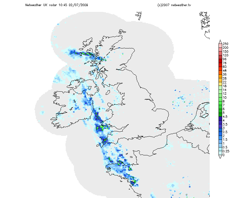 Radar images from Netweather.tv
Click on the image for a larger version.
I thought it would also be good to post it on here as well, so you can see the track that the storm took through the day.
The animation starts at 10:45 in the morning, through to 18:45, in hourly radar images.
Radar images from Netweather.tvClick on the image for a larger version.
Monday, 6 July 2009
THUNDERSTORM WARNING
Hebrides Weather currently tracking three thunderstorms, two off the Scottish East Coast and one near St Kilda, west of the Outer Hebrides.
There are also storm cells in the central Highlands but the mountains are blocking these strikes from our sensors.
The storm near St Kilda has only been active for the last few minutes but there have been a high number of cloud to ground strikes from this storm. The track of this storm in yet unknown so for the latest updates go to our Lightning page.
Update:
Radar indicates that the St Kilda storm cell should move southwest away from the islands and out into the Atlantic.
The Storm cells in the North Sea could head NNW and come inshore during the early afternoon.
Saturday, 4 July 2009
Thunderstorm Warning
Hebrides Weather is currently tracking a Thunderstorm in the area of Cape Wrath/Durness that seems to be tracking West into the North Minch and towards Ness & the Butt of Lewis.
The storm is giving upto 15 strikes per minute and nearly 200 strikes in the last 30 minute.
You can follow this storm on our Lightning page.
The storm is giving upto 15 strikes per minute and nearly 200 strikes in the last 30 minute.
You can follow this storm on our Lightning page.
Friday, 3 July 2009
Weather Warning for Highlands & Eilean Siar
Heavy Rain: Valid from 1600 Fri 3 until 2359 Fri 3
Heavy thundery rain will be spreading across these areas later this afternoon and this evening. Up to 30mm could fall locally.
Issued at: 1515 Fri 3 Jul
More information is available from the UK Met Office.
Keep watching the Lightning & Radar pages on Hebwx for the latest.
Heavy thundery rain will be spreading across these areas later this afternoon and this evening. Up to 30mm could fall locally.
Issued at: 1515 Fri 3 Jul
More information is available from the UK Met Office.
Keep watching the Lightning & Radar pages on Hebwx for the latest.
Thursday, 2 July 2009
THUNDERSTORM ALERT!
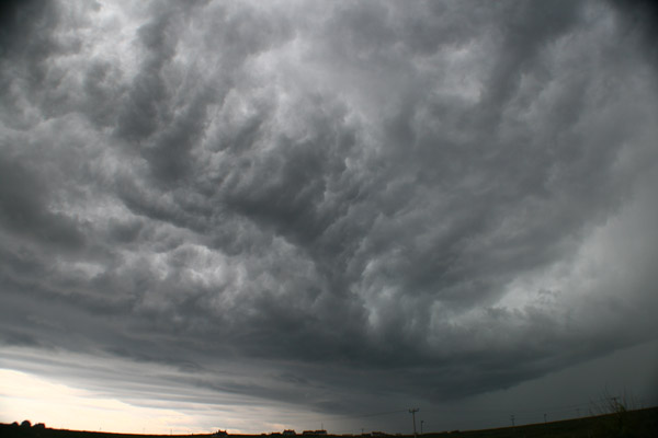
Large thunderstorm over Skye heading North.
Hebrides Weather is currently tracking 4 storms with upto 29 strikes per minute.
Photo of the leading edge of the storm.
Hebrides Weather is currently tracking 4 storms with upto 29 strikes per minute.
Photo of the leading edge of the storm.
Monday, 29 June 2009
New Dashboard on the Homepage
The observant amongst you may have noticed that the dashboard (information area) on the homepage of Hebwx has been enhanced with some extra data.
Anything that you're not sure about then just post a comment on here and I'll be happy to explain it for you.
Anything that you're not sure about then just post a comment on here and I'll be happy to explain it for you.
Sunday, 28 June 2009
Lightning Data
There are some new features for the lightning & thunderstorm detection.
At the top right of the sub-header you'll see "Nexstorm:......." that shows if any thunderstorms are being tracked at the moment.
There's a short version of the TRAC report at the top of the Homepage and on the Lightning page, the short version of the TRAC report is again at the top of the page with the full version further down.
Wednesday, 24 June 2009
Weather Warning - Highland
Flash warnings of severe or extreme weather.
Valid from 1200 until 2100 BST on Wednesday 24th June.
Scattered or isolated heavy showers will develop this afternoon, mainly in the west of the area. Accumulations of 10 to 15mm are possible within 1 hour, perhaps 30mm in total as the showers will be slow moving. The showers will die out during the evening.
This warning is for Highland Region only, Eilean Siar is not currently under a warning.
Further information on these warnings are available from the Met Office.
Tuesday, 23 June 2009
Live Weather Outage
I've just noticed that the weather PC locked up at 05:31 this morning and I've been busy doing other things so it's taken until now before I noticed.
I'm just running a few processes before I restart everything but it should all be back up & running by 17:00.
Update: All is now well on the live weather side and normal service has been restored.
The systems will be monitored for the next 24 hours.
Sorry of any inconvenience.
I'm just running a few processes before I restart everything but it should all be back up & running by 17:00.
Update: All is now well on the live weather side and normal service has been restored.
The systems will be monitored for the next 24 hours.
Sorry of any inconvenience.
Wednesday, 17 June 2009
Wunderground Forecast
I've added another forecast to the website, this is the forecast for Stornoway from Weather Underground. As I contribute my data to Wunderground and upload my webcam image for them to use then they have given permission for the use of their forecasts in return.
So now you can compare my own forecast to that of Wunderground, both can be found in the Forecast & Advisories area in the menu.
So now you can compare my own forecast to that of Wunderground, both can be found in the Forecast & Advisories area in the menu.
Forecasts now show MPH
I've updated the forecast so that they now show MPH for the wind speed instead of Knots.
I had been thinking about doing this as part of the website revamp but after Richards comment asking about having the forecast of the Printable Flyer in MPH & Knots then I decided to change.
I'm going to try & do this with the whole site but this means doing convertions as I want to keep my own records in Knots. The live weather isn't so bad as you can set your own units to be displayed (click on the "Units" button at the bottom of the screen), it's the likes of the main dashboard. I'll look into this and post on here if I find a way to change this as well.
Comments & ideas welcome.
Martin
Monday, 15 June 2009
Weather Flyer
Hebrides Weather has now introduced the Weather Flyer which contains the latest satellite image, detailed 2 day forecast for the Stornoway area and a 5 day outlook on graph format.
This Weather Flyer is designed to be printed onto an A4 sheet and can be displayed by local hotels, guesthouses and companies for the convenience of their guests and visitors.
Please let us know if you use this new facility and any feedback is welcomed.
This Weather Flyer is designed to be printed onto an A4 sheet and can be displayed by local hotels, guesthouses and companies for the convenience of their guests and visitors.
Please let us know if you use this new facility and any feedback is welcomed.
Welcome
This is the new Hebrides Weather website blog and has been setup so that you can be kept informed about what's new on the site and what the updates are.
Regular visitors to www.hebrides-weather.co.uk or www.hebrides-photos.com/weather/ may have noticed a change in the URL and a new website.
The old site was getting too large to be tagged onto the Hebrides Photos website so it now has a new URL (www.hebwx.co.uk) and site layout.
The main work is now complete but there will be some tweaking taking place over the next few weeks. Feedback on the new site is most welcome so feel free to comment in this Blog or by using the Contact form on the website.
Subscribe to:
Posts (Atom)


